Data
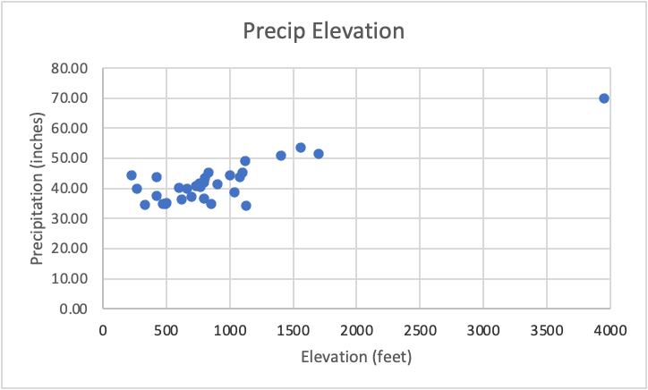
There is a moderately strong positive relationship between precipitation and elevation (R2=0.71). The arithmetic average precipitation is 42.15 inches for the state of Vermont and the Winooski river basin average is 44.29 inches. This average was calculated using the station normal values from within the Winooski watershed. The size of the Winooski basin is 1044 square miles and the total volume of annual precipitation is 3.03 cubic kilometers. The mean annual Winooski river discharge is 1817.35 cubic feet per second and the total runoff volume is 0.011 cubic kilometers with a percent runoff from precipitation of 0.35%. The mean annual TDS and TSS values in tons per square kilometer per year were 42.44 and 42.83 respectively.
The relationship between rainfall and runoff and “missing” water in the Winooski River basin differs due to factors within the watershed that prevent all of the water from becoming groundwater via infiltration. Not all water gets infiltrated into the ground and the amount of impervious surfaces within the basin can have a strong impact on runoff. Much of this “missing” water gets redirected into other parts of the Winooski River watershed; this includes streams and rivers that make up parts of the subwatershed. Water can also flow into Lake Champlain of which the Winooski River is a subwatershed itself.
There are similar mass values for TDS and TSS suggesting that fluxes of the suspended load mass moving out of the Winooski river basin are similar to fluxes of the dissolved load. The rate of mass removal for the Winooski River is lower compared to that of the Cuba basins in the GSA paper. These rates differ due to geological, geographical, and climactic differences as Cuba is a subtropical climate with different bedrocks, rates of weathering and topography.